Fit City

Tag Image: 

Turning down the heat, turning up the green

Cooling off the hottest & dirtiest places in the region

August 26 2015

You’ve talked about it with your neighbors over the fence and with friends at the cookout: It’s been a pretty hot summer in the Portland area. 

On some of the hottest days, I like to get in the car and drive around with Jackson Voelkel, a geospatial research analyst in my Sustaining Urban Places Research Lab at Portland State University, and Dr. David Sailor, a PSU engineering professor. It’s not just any car. It’s outfitted with sensors and temperature gauges, allowing us to locate in real time the hottest spots in Portland. 

We’ve been working with a team for several years to develop heat island maps for Portland and its surrounding region. We’ve also worked with Dr. Linda George and her lab to study traffic-related air quality, and the impact of trees on that air quality. These two environmental measures help us identify the hottest and dirtiest places throughout The Intertwine, and who is particularly at risk for health problems during high-heat events. 

Last year, we were approached by the PSU Institute for Sustainable Solutions about working with the Portland Bureau of Planning and Sustainability as part of the Portland Climate Action Collaborative. The idea was to take some of our research on heat island and air quality mapping and make it applicable for city officials and public health managers looking for ways to reduce respiratory illness and other negative—potentially fatal—impacts during Portland’s heat waves. We were especially interested in reducing harm to the most vulnerable populations: the elderly, people with asthma, and children and babies. 

What many people don’t realize is that there are more deaths attributed to urban heat in the United States than all other natural disasters combined. Evidence from places where hundreds of people have died, including Chicago, St. Louis, and throughout Europe, suggests that many of those deaths occur in populations with preexisting health conditions, but also impact those with fewer financial resources to take measures like installing air conditioning. Combine a hot day with dirty air, and we have a lethal recipe for any urban community, including the Portland region. 

Yet the challenge for public health workers, we learned, is to find the places where heat islands, degraded air quality, and vulnerable populations exist in the same place. At the same time, the challenge for planners is to consider the policy and design options that can cool and clean city neighborhoods. 

By layering demographic data on top of our heat island and air quality maps, we’ve been able to uncover the factors that contribute to human vulnerability. It’s no surprise that wealthy neighborhoods with mature trees, such as Irvington in Northeast Portland, Ladd's Adddition in Southeast Portland, and Portland Heights in Southwest Portland, are much better off than lower-income neighborhoods with less greenery, such as Cully in Northeast Portland, Foster-Powell in Southeast Portland, and St. Johns in North Portland. Perhaps surprising is that the same system of inclusion and exclusion of tree-filled neighborhoods has the same results in the 12 other U.S. cities we’ve studied. In other words, the current climate adaptation picture isn’t very equitable.

Approved earlier this summer by Portland City Council and Multnomah County, the 2015 Portland Climate Action Plan includes our layered maps (on page 112). We believe that sharing our timely research with the city and county was a first step in helping us to understand what strategies, programs, infrastructure, and policies need to be put in place to ensure a more equitable approach to climate mitigation in the region. 

Right now we’re working on an interactive version of the map that will help policy makers and citizen groups drill down on specific Portland streets and neighborhoods to find trouble spots. Notable in our analysis is that trails and greenways factor prominently in reducing air pollution and mitigating urban heat. The more extensive tracts of greenery present in specific areas, the greater cleaning and cooling of the air. Our wish is that such interactive maps will help generate a conversation about areas of the city that need attention, to work with local organizations to bring awareness about environmental conditions, and ultimately to take action to cool and clean the city, one neighborhood at a time. 

There are several ways to cut down on heat island effects in urban areas. You can reduce the reflectivity of surfaces, such as changing a black parking lot or rooftop to a lighter color; reduce the amount of connected concrete in a neighborhood; and, of course, plant more and greater continuity of trees. We are in the process of developing an approach that brings together existing information about effective strategies as part of a tailored online mapping tool. We expect to release the tool this winter 2016. 

We also want to know where urban tree planting can have the most positive impact. Recently the SUPR Lab released the Trees and Health APP, an online tool that allows anyone to scan city neighborhoods and find the ones most in need of trees. The APP, which stands for Assess, Prioritize and Plan, is part of a U.S. Forest Service-sponsored project named Healthy Trees, Healthy People. So far, the tool is available in 13 cities, including Portland, and we would like to expand it to more. We would welcome members of the Intertwine Alliance to use and evaluate the tool by assessing the extent to which your specific goals align with the current challenges facing the region. 

I’m thrilled to see attention being given to the relationship between nature and health, especially the role of trees as part of our healthcare plan. I’m noticing that the health and well-being benefits of urban trees are getting into the mainstream media, and that policy makers and citizen groups are paying attention. 

So as you talk to your neighbors and friends about the hot summer, you might also consider asking them about how your neighborhood can accommodate more trees. You might be surprised by their responses!

Vivek Shandas is an Associate Professor in the Nohad A. Toulan School of Urban Studies and Planning at Portland State University. He's also founder of the Sustaining Urban Places Research Lab and a Fellow of the PSU Institute for Sustainable Solutions. A former health and environmental policy analyst for the governor of New York, Vivek’s focus is on urban sustainability.

Cycling the city on a cool August day

August 15 2015

Yes, Washington D.C. now has twice as many miles of protected bike lanes as Portland.

Birmingham, Ala. -- not the Rose City -- launches bike sharing in September.

And Minneapolis? When it comes to cycling, says Steve Durrant, a senior landscape architect at Alta Planning + Design in Seattle, "Minneapolis completely puts (Portland) to shame."

Resting on our laurels? Perhaps. But on the coolest day in August, Cycle Oregon and The Intertwine Alliance took almost 200 of the area's "policy makers" on a rousing tour of those laurels, a 15-mile ride that former Mayor Bud Clark summed up rather well:

"I'm old," says Clark, 83, armed with a Kalkhoff E-Bike and a Nutcase watermelon helmet, "and in awe of the situation."

Clark was aboard for the first policy maker ride; Durrant helped plan that 2005 slog from the Hawthorne Bridge to Champoeg State Park. "It was a good, bad and ugly ride, and there was a lot of ugly," Durrant said Friday during a break for lemonade at the Lucky Lab. "There were so many roads that were hostile."

The 11th annual odyssey was far more accommodating for the peloton of bike advocates, city planners, transportation strategists and networking entrepreneurs. From the Moda Center, the ride looped through North Williams, the Pearl, the North Park Blocks and South Waterfront, before a memorable stop at the watershed restoration project at Westmoreland Park and the turn home on the Springwater Corridor.

From the beginning, the ride has been designed to connect the dots between what's on the ground, what's in the works, and what's on the visionary drawing board for cycling and alternative transportation.

The emblematic apex of the 2015 ride was Tilikum Crossing. No corner of the city is better designed than South Waterfront for the ebb and flow of buses, cyclists and pedestrians, a mix that will only intensify when the striking 1,700-span over the Willamette River opens Sept. 12.

It's "a symbol of what you have been working for all these years," Rep. Earl Blumenauer, D-Ore., told the crowd at the Moda Center. He then added:

"When we cut the ribbon on that bridge, it will be the first time in 50 years that we don't have a major federal project in the pipeline."

For the foreseeable future, the city is largely on its own. Congress can't find the means to maintain the bridges and highways collapsing beneath the weight of trucks and cars, and too few of its hostile policy makers were along for Friday's showcase of the urban alternatives.

The ride illuminated the work that remains to be done on the Willamette's west bank. North Williams is one of the city's busiest commuting corridors, and 40 percent of the traffic during rush hour now pedals in the cycling "superhighway."

The increasingly frantic desire to live three blocks off Southeast Division Street may owe as much to the ease of cycling through the adjacent neighborhoods as it does to Bar Avignon and Ava Gene's. When Rich Fein arrived from Akron, Ohio, 18 months ago, he opened Cynergy E-Bikes at Southeast 39th and Powell: "If you're going to sell bikes," he says, "where else would you go?"

But the central city is harder to negotiate. Ian Stude, the director of transportation and parking at Portland State University, said there's a simple reason why so many of the students who could bike to the urban campus don't:

"It's not convenient. It's not intuitive. And it's not safe," Stude says. "The solution is far more about commitment and politics than engineering. When we look at this public space, what do we choose to prioritize? We've prioritized movement over safety."

Small adjustments are in the works.  The Portland Bureau of Transportation is still deciding how to best spend $6 million in multimodal funds. The "Green Loop," a 6-mile "active-transportation" park, may yet bring better cycling access to the pedestrian-friendly Park Blocks.

"When you move through the central city on a bike, it changes your experience with the city," Stude said. And that's an experience eagerly sought by the thousands of people who -- the aggressive bike cultures in Minneapolis, Birmingham and the nation's capitol notwithstanding -- are Portland-bound.

Reprinted with permission of The Oregonian.

Steve Duin is The Oregonian's Metro columnist. He is the author/co-author of six books, including "Comics: Between the Panels," a history of comics; "Father Time," a collection of his columns on family and fatherhood; and a graphic novel, "Oil and Water." His last name, for inexplicable reasons, is pronounced "Dean." Blog: www.oregonlive.com/duin​. This column is reprinted from the 8/15/2015 Oregonian, with permission of the author.
 

Discover hidden gems north of the Columbia

Celebrating 30 years of the Clark County Legacy Lands Program

April 29 2015

Many are familiar with the Vancouver Lake lowlands and Ridgefield National Wildlife Refuge in Clark County, Washington, together a mirror image of the Sauvie Island complex on the Oregon side of the border. Clark County, along with federal, state and non-profit organizations, has assembled key pieces of the lowlands over a 30-year period as a conservation legacy for future generations. Vancouver Lake and Ridgefield are two of the best known natural areas in the county, but there are many others to discover. 

Clark County’s Legacy Lands Program, managed by the Environmental Services Department, was instituted in October 1985, when the Board of County Commissioners adopted a small property tax levy of 6.25 cents per $1,000 of valuation to protect open space from threats such as urban development and habitat degradation. Protected greenspaces provide a vital green infrastructure that connects our community, protects our water and air, preserves corridors for wildlife, and provides recreational opportunities.  

To celebrate 30 years of success, we hope to introduce you to three less familiar gems in our system. Directions to and information about sites highlighted below, and other engaging natural sites, can be found at www.clark.wa.gov/legacylands. We are also programming a series of special events throughout 2015 to pique your interest in our unique contributions to The Intertwine.

La Center Bottoms and the Lower East Fork Lewis Greenway

The free-flowing East Fork of the Lewis River is home to native runs of Chinook, Coho and Chum salmon, and winter and summer steelhead. The lower floodplain offers hundreds of acres of bottomland habitat for waterfowl and other species. Clark County and its partners have assembled more than 2,000 acres of land from the confluence of the East Fork and North Fork Lewis Rivers to Lewisville Park near Battle Ground. While much of this land is protected for its habitat value and has limited public access, La Center Bottoms offers a window into this bottomland system. 

From the trailhead on 3rd St. in La Center, follow the handicap-accessible path to a small bridge across a burbling brook in an oak stand. Past the bridge, the path turns to gravel. Soon you will arrive at a waterfowl viewing blind where you may see migrating tundra swans feeding on camas bulbs in the wetland ponds. Migrating salmon smolts also use the ponds for refuge and forage. From the large bridge across Brezee Creek, there is an expansive view of the bottomland landscape. As you look upstream, know that most of the bottomlands on the south side of the river are protected. Continuing over the bridge, the trail narrows and follows the levee, providing more intimate views of the river. 

For an on-water experience, the City of La Center has constructed a small canoe/kayak launch just under the La Center Road Bridge downstream of the trailhead. This reach of the river is tidally influenced. Time it right, and ease your upstream paddle on the incoming tide. Then drift downstream with the current back to the put-in, or, for the adventurous, all the way to the Columbia River, ducking into Lake River to a take-out at the Port of Ridgefield. 

Salmon-Morgan Creeks Natural Area

For an upland experience, explore the 81-acre Salmon-Morgan Creeks Natural Area in the southwest corner of Battle Ground. Ancient cedar stumps, harvested in the early 1900s, nurse a new generation of life. A mature mixed-conifer forest has grown up around them, offering a variety of experiences. You might hear the drumming of a pileated woodpecker echo through the forest. You might stumble across a rough-skinned newt crossing one of the soft surface trails. Trilliums brighten the forest floor in spring. From an overlook, you can view the confluence of Salmon Creek and its tributary, Morgan Creek. Western pearlshell mussels can be found in Morgan Creek, and Coho salmon smolts rear under the cooling forest canopy well into summer.

Lower Washougal Greenway

The Lewis and Washougal River systems are the two primary systems we expect to contribute to the recovery of salmon and steelhead populations in Clark County. The City of Camas, Clark County and other partners have managed to assemble an 100-acre greenway along the Lower Washougal River. The City recently completed a 1.5 mile-long handicap-accessible trail from which you can get a first-hand view of the river. 

From downtown Camas, travel east and turn right onto NE 3rd Loop, just past Lacamas Creek, to the trailhead. A short downhill switchback will take you to a boardwalk that lightens the impact of foot traffic through the floodplain. During the spring freshet you might get wet feet. Ascending out of the floodplain, a bridge leads you from the north bank to the south bank of the river. Spectacular views up and down the river await from the top of the bridge. February through May you might see salmon and steelhead spawning in the gravels below. The trail continues through a reclaimed gravel mine that is now a series of ponds connected with the river and enhanced with large wood to improve fish habitat. Shortly past the gravel mine, the eastern trailhead awaits off of NE Yale St.

For a longer outing, check out the trailhead for Lacamas Lake Regional Park and its 9.5 mile trail system, one block west of 3rd Loop on 3rd St.  

Patrick Lee is a greenspaces geezer, proud of his accomplishments to date and excited about the work to come. He coordinates Clark County’s Legacy Lands Program.


Does The Intertwine create jobs?

Let's hear what the job creators have to say.

April 8 2015

Most of us have heard stories of area firms that locate to the Portland metro region because of our natural amenities. Tales are told of CEOs who brought their companies here because they find our commitment to nature a good fit for their business ethos, or because they love running trails or want their employees to be able to bike to work safely. 

We’ve heard the stories -- but up until now they’ve been just that: stories. They are anecdotes we pass along as evidence of something we sense is true but can’t quite prove.  

We gave Hatfield Fellow Joe Otts eight months to substantiate the link between The Intertwine and jobs. If he failed to find such a connection, we promised to quit repeating these stories! Here are 10 things we learned from Joe’s work:

1. Our nature-pioneering has helped launch new companies. The intellectual capital that The Intertwine has developed through our pioneering efforts, both public and private, has spun-out companies specializing in green roofs, active transportation and other green technologies. Further, we’ve strengthened the offerings of architecture and engineering firms in the increasingly lucrative markets for sustainable design and construction. Elaine Kearney, technical director for Columbia Green, talks about how the pioneering work of Portland’s Bureau of Environmental Services and others helped launch this Portland green roof company. 


2. The Intertwine is a living laboratory for testing gear. Whether it is testing the latest KEEN hikers on the Wildwood Trail, or challenging Columbia’s high tech fabrics in a downpour on Cooper Mountain, The Intertwine is part of the product-testing infrastructure for our booming outdoor and athletic industry. Outdoor and athletic, an “alpha cluster” in economist-speak, generates 14,000 jobs and $1.2 billion in annual payroll. Scott Welch, global corporate relations manager for Columbia Sportswear, speaks about the importance of The Intertwine to his company's product testing. 


3. The Intertwine bolsters brands. Area companies report that Portland’s national and international reputation rubs off on them. The Portland region is known for being smart about how it incorporates nature into its urban environment. Being from the Portland area associates you with that ethic, which translates into brand value and sales. Dylan VanWeelden, marketing manager at bike part company Chris King Precision Components, talks about the value of the Portland brand. 


4. The Intertwine is a “second paycheck.” What employer wouldn’t love a little help meeting payroll? Well, this isn’t quite that, but employees do report that living in The Intertwine is like getting two checks instead of one. Joe completed an informal survey of area firms, with particular emphasis on technology companies (thank you, Technology Association of Oregon!) and outdoor and athletic (thank you, Portland Development Commission!). The value that employees put on that second check is higher than you might guess. See the results for the technology sector here. (Other sectors showed comparable results.) 


5. The Intertwine demonstrates corporate ethos. Area firms report that locating to the Portland region, and being part of the region’s culture of stewardship, can be an authentic demonstration of corporate ethic. By “walking the talk,” companies strengthen their culture and build credibility with customers and employees alike. Here’s more from Scott Welch.


6. The Intertwine provides inputs to production. Clean water, especially, is a key input for everything from making chips to brewing beer, and nature is the most effective means anyone has ever discovered to deliver clean water. Brewmaster Christian Ettinger of Hopworks Urban Brewery sings the praises, and explains the importance, of Bull Run water. 


7. The Intertwine helps companies attract talent. Our investments in parks, trails and natural areas gives our companies an edge in attracting talent. In fact, these amenities are one of the top reasons prospective employees are attracted to Portland companies. Kristin Dagg, talent acquisition team leader for Columbia Sportswear, often leads with information on The Intertwine when recruiting out-of-area talent She also reports  that many of her recruits are “pre-sold” on the Portland regio, making her job that much easier. (Hear more from Kristin Dagg.)

Here’s more on this topic, from Intel Talent Advisor and Executive Search Recruiter Don Cooper.


8. The Intertwine helps companies retain talent. Perhaps even more significant than The Intertwine’s power to attract talent is its power to retain it. In Joe’s informal survey, we discovered evidence that the value employees place on The Intertwine grows over time. Here are the survey results for the outdoor athletic industry and the technology industry.


9. Even ranked against other great reasons to live here, The Intertwine rates as a primary factor in technology-sector talent coming to town. With the support of the Technology Association of Oregon, Joe was able to gather information from 130 area technology employees on what was most important to them in their decision to live in Portland. Even we were surprised by the results. 


10. We have competition! Other metropolitan regions are developing their own “Intertwines.” We can’t expect to remain a market leader without continuing to invest. Intel's Don Cooper has this to say. 


We recognize that much is left to do in deepening and validating these results, but we thank Joe for unearthing such great information and giving us such an excellent start. This project was funded by Metro and managed by The Intertwine Alliance. Joe’s full report is now available for download, or read his summary.

Intertwine Alliance Executive Director Mike Wetter has directed the coalition since its early days as a Metro initiative, before it became a formal nonprofit in 2011.  Mike was chief of staff to former Metro Council President David Bragdon, and a business consultant for 13 years serving public, private and nonprofit clients. A visionary leader full of creative ideas, he's an avid whitewater rafter, kayaker, cyclist and hiker.

How we get there matters

The case for regional investment in active transportation

March 4 2015

Many of us remember walking or bicycling to and from school as children. In fact, a generation ago, in 1969, nearly 50 percent of the U.S. population did so. Today that figure stands at 13 percent.

There are a number of reasons for this drop, and one of them is a lack of sidewalks, crosswalks, safe bike lanes, and other student-friendly infrastructure around our schools. As it turns out, it’s not just students who are having a hard time getting around. 

It’s no secret to anyone who’s thought about or tried it: There are far too many places in our region that you cannot walk to, or from, and where most people would never, ever consider riding a bike. It’s probably not a coincidence that although 18 percent of us in the Portland metropolitan region choose to walk, bicycle and use transit to get to our destinations, little more than half of all roadways in the region have sidewalks on both sides of the road. And we spend only 3 percent of our total transportation budget on walking, bicycling and trails projects. 

The reality is that too often transit-access projects, projects that improve safe routes around schools and neighborhood centers, and projects that provide healthy options for traveling distances shorter than 3 miles (which account for 44 percent of all trips, and could easily be replaced by walking or bicycling) have not traditionally been successful in a constrained funding environment. The reality is that most people do not recognize or understand the benefit of solidly investing in active transportation projects, or of the benefit they bring to the transportation system we all rely upon.

We have some work to do if we are to reach our regional and state goals of more people walking and bicycling, improved freight mobility through reduced traffic congestion, and lower tailpipe emissions. 

The Intertwine’s Active Transportation Forum held in January was but one piece of an ongoing conversation under the banner idea that how we get there matters. After a panel of eight presenters each “made the case” from their unique perspectives — including health, travel-demand management, economic benefit and more — participants dove into table discussions to help frame the answer to the question, “How should we define walking, bicycling, trails and transit-access transportation projects in order to succeed in a constrained funding environment?”

We know there is a great need to continue these conversations, and to add to them, which was confirmed by the energy in the room and the difficulty keeping the conversation to one topic at a time. We are already at work planning the next forum, and welcome your input. 

Over the next few months, comments and ideas gathered during the “How We Get There Matters” forum will be analyzed and refined into a report to be made public here. It will focus on the outcomes from active transportation projects and how they can be better laid against our region and state's goals for transportation, health, climate, community, equity, environment and more. The report aims to provide outcomes and criteria demonstrating the regional significance of active transportation and transit access projects. 

The Metro regional goal is to triple the percentage of people choosing to walk or bicycle to 36 percent by 2040. How we get there does matter!

With a background in cultural anthropology, an interest in the effects of transportation choices on our health and the environment, and two boys under the age of 6, Kari Schlosshauer has brought a diversity of experience working around the globe to her role as the Pacific Northwest Regional Policy Manager for the Safe Routes to School National Partnership. She works in the Portland and Salem metropolitan regions and Southwest Washington to increase funding opportunities and improve transportation policies that support safe, healthy walking and bicycling opportunities for children and families. http://saferoutespacificnorthwest.org

Fall means fútbol in our parks

Across The Intertwine, social changes shape our sports fields

October 29 2014

After a long, hot summer, the weather is finally changing. The fall season is here, bringing with it foggy mornings, pumpkin-flavored treats everywhere, and increased utilization of park space by sports enthusiasts.

Immigrants like me make up a significant number of the people vying to use The Intertwine's available park space for sport practice. And for the majority of us there is one sport that matters: soccer, or fútbol, as Spanish-speakers call it.

I grew up in Ecuador and my earliest sports-related memories are of my family watching important fútbol matches together.  When I moved to United States in 1993, I knew that soccer was not high on the list of most popular sports for Americans. However, the lack of interest I found in Corvallis, where I first lived here, still amazed me.

My Oregon friends assured me that Portland was different: Soccer City USA. But despite their stories of the old Timbers, the North American Soccer League, the games Pelé played in then-called Civic Stadium, something about it all seemed very distant.

When I moved to Portland in 1996, I found the passion I was looking for in a few scattered sports bars around town, where small but loud crowds, decked out in their countries’ team’s jerseys, screamed their lungs out. I also found that passion in neighborhood parks like Lents, Rockwood Central, and Fairview, where I saw Latinos and other immigrants coming together in any available open space to form soccer teams, and playing one another primarily on weekends.

In the late 1990s, when I worked at an east Multnomah County social service agency, I became aware that there were conflicts for park space utilization between these pick-up soccer games and the locals who practiced other sports, situations, according to the Latino immigrants I worked with at the time.

This is because fall is not just soccer season, but also American football and rugby season, which meant that there was a lot of competition for those open spaces. This problem was compounded by lack of awareness of the rules to reserve and rent park space, different expectations about trash disposal and language barriers – resulting sometimes in tense situations.

It’s a tension that, fortunately, seems to be on the decline.

Since 1990, the Portland metropolitan region has experienced significant growth in the number of Latinos and other people of color. Parallel to this demographic change, soccer has also gained in popularity and is now one of the nation’s top five most popular sports for both youth and adults.

Perhaps as a direct result of these changes in demographics and sports preference – as well as active outreach by parks and recreation districts to immigrant communities, and the development of more multi-sport park space – my friends and I have observed these conflicts over park space to be less common these days.

A great example of these successful outreach efforts is Portland Parks & Recreation’s Portland World Cup program, which seeks to celebrate the diversity of Portland’s immigrant and multicultural communities through soccer, employing the sport to better integrate recent immigrants, especially youth, into the fabric of the city.

This annual competition started in 2010, and in the 2014 tournament 20 teams (16 boys and 4 girls) with a total of 400 youth participated, representing a similar number of countries and languages.

Eight young people from Haiti, Burma, Croatia, Mexico, Morocco, Democratic Republic of Congo, and Portland participated in the organization of the Portland World Cup.

Tournament participants (and the adults in their lives) had the opportunity to share their cultural knowledge and values, develop partnerships among themselves and long-term. Portland residents, and learn more about the City of Portland and other organizations.

Soccer can be a powerful tool not just to learn the intrinsic values that any sport can teach – hard work, teamwork and good sportsmanship – but also to show people from all over the country a way to come together.

In the open spaces of our parks, shouting and sharing deep lungfuls of fresh air, we can celebrate the diversity of The Intertwine by sharing in a game beloved all over the world. Fútbol is for everyone.


Juan Carlos Ocaña-Chíu  is the Equity Program Analyst at Metro, where he works closely with community-based organizations to find creative ways to measure equity throughout the region. He lives in Portland's Lents neighborhood.


Scenic Bikeways and Bottom Lines

Oregon bike tourists impact more than singletrack

September 17 2014

Did you know Oregon is the only state in the nation with an official, state-run Scenic Bikeways program? That’s right; similar to our Scenic Byways program (which highlights key routes for cars) we also have 12 designated Scenic Bikeways.

If you’ve never ridden a Scenic Bikeway, I highly suggest you consider doing so. As an everyday bicycle commuter in the city of Portland for over a decade, I understand how easy it is to get caught in the rhythm of using one’s bicycle just to run errands or get to and from work. But it’s also important to occasionally get on your bike just for the pure joy of the ride.

This fall, why not nurture your inner child on the Covered Bridges Scenic Bikeway (one of my favorites for its family-friendly off-roading, great foliage and path through historic downtown Cottage Grove)?

Or better yet, head to RideOregonRide.com and plan a several day trip next year on any one of the longer Bikeways such as the Old West Scenic Bikeway, Blue Mountain Century, and the newest of all—the Cascading Rivers Scenic Bikeway.

Trust me; your pleasure trip does your state a favor. In 2012, a Dean Runyan Associates Economic Impact Study revealed that bicycle travel spending reached $400 million in Oregon—that’s approximately $1.1 million per day! Travelers who participated in bicycle-related activities spent:

  • $72 million on motor fuel
  • $54 million on groceries
  • $32 million on event fees
  • $28 million on bicycle repairs, clothing & gear
  • $175 million on accommodation & food services

In addition, this bicycle-related travel spending directly supported about 4,600 jobs, resulting in $102 million in earnings. The spending also generated local and state tax receipts of nearly $18 million in 2012. This includes lodging taxes, motor fuel and travel-generated state income tax.

This year, in an effort to better understand the significance of the Bikeways program, Travel Oregon and Oregon Parks & Recreation Department (OPRD) are launching a new economic impact and user study—expected to be released in spring 2015—in partnership with Dean Runyan and the Oregon Department of Transportation. The goals of the 2014 Bikeway Study are to:

  • Know what the economic impacts of the Bikeways are to Oregon;
  • Provide input to help make Oregon an even better place to ride;
  • Learn more about the bicycle traveler in Oregon; and
  • Provide useful data for our partners and networks to utilize.

The study has two key components, including a Scenic Bikeway Trail Counts, which took place this summer, and a Scenic Bikeway Survey.

The Scenic Bikeway survey is intended for all cyclists to participate in who have ridden their bike, or plan to ride their bike, on any one or more of Oregon’s Scenic Bikeways during 2014. Answers supplied will be kept strictly confidential and be used for statistical purposes only; the survey takes approximately 7 minutes. Take the survey here!
 

Nastassja Pace is Travel Oregon’s Destination Development Specialist. In addition to supporting the sustainability program Travel Oregon Forever, Nastassja helps lead Oregon’s bike-tourism development efforts. She serves on the Scenic Bikeway Committee, convenes the Oregon Bicycle Tourism Partnership, co-facilitates Bicycle Tourism Studios, manages the Bike Friendly Business program, and aids in the development of RideOregonRide.com. Nastassja has worked on campaigns including “Ban the (Plastic) Bag,” and serves on the board of Portland-based nonprofit We Love Clean Rivers.

Green Time

Can research prove nature's healing power?

November 6 2013

Here in The Intertwine, we’re fortunate that our forests, streams and parks give us endless options for exploring the world via foot, pedal and paddle. Most of us suspect that getting outside is a healthy thing to do. What we may not know is that an increasing number of researchers are studying the health benefits of nature – building our knowledge base, validating conventional wisdom, and offering insights for policymakers, health professionals, parents, and more.

It might be awhile before “Green Time” is integrated into our healthcare system. In the meantime, I invite you to leaf through some of the pioneering work that’s changing the way we think about health and nature:

1) Physical Health – Good for our Bodies.

Whether hiking to the top of Council Crest, bike-commuting along the Springwater Corridor, or canoeing the Tualatin River, physically activity outside burns calories, exercises the heart and muscles, and releases endorphins. Research from the U.K. shows that people that engage in nature-based Green Exercise are more likely to exercise longer, more frequently, and feel better about themselves for doing so than people running on an indoor track or treadmill. Resources like The Intertwine's Find Adventures feature can help people discover such experiences right out their front door, regardless of their physical abilities.​

2) Mental Health – Good for our Minds

Just being outside can have profound effects on our health and well-being.  The calm and quiet of the woods, the river or even a park are relaxing and mentally restorative. Studies demonstrate that exposure to even small amounts of nature (like a few trees) or simulated nature (such as a photo) can increase a person’s concentration, attention, and productivity.

While this research supports conventional wisdom about the value of connecting with nature, other studies on psychological state are provoking even more excitement in the medical community. Individual- and population-based studies have shown that increased contact with nature can improve mood, a sense of vitality, and even positively affect medically-diagnosed conditions like depression and anxiety.        

3) Social Health – Good for our Communities

Other research indicates that green spaces can help us be better neighbors and create safer, healthier places to live. The presence of trees and other vegetation creates a more pleasant aesthetic environment and has been shown to increase social interactions and sense of community. Trees are also associated with a reduction in crime rates, including in Portland neighborhoodsExposure to nature can also shape a community’s social fabric by increasing individuals’ feelings of generosity and altruism.​

Much of this scientific work has been championed by researchers like Roger Ulrich and Geoffrey Donovan, as well as author Richard Louv and scholar Tim Beatley. Organizations such as the Trust for Public Land and the National Recreation and Parks Association have begun incorporating these ideas of health into their literature, and even the American Academy of Pediatrics has accepted the importance of getting people outside and connected with nature.

So next time you’re wondering if you need more Green Time, know that a wealth of evidence supports the healing power of nature. Now go out there and enjoy it!

Kurt Beil, ND, LAc, MPH is a holistic physician and researcher at the National College of Natural Medicine (NCNM) in Portland. His research focuses on Environmental Psychophysiology. For his Master of Public Health field project at Portland State University, he worked with Kaiser Permanente and Metro to investigate the potential public health benefits of The Intertwine.  He can be contacted by email.

Pedal-ready

East Multnomah gears up for a new kind of tourism

October 2 2013

I stopped riding my bike about 15 years ago, due to a busy career and parenthood in San Francisco coupled with a strong disinterest in riding up hills. When I moved to Portland three years ago, I told friends who pestered me to ride that I wasn’t comfortable biking in traffic. Frankly, I could think of many other ways to exercise, socialize, and get outside. Biking just seemed like too much discomfort to deal with. But July of this year, I finally acquiesced, riding the Springwater Trail with a friend between Gresham and Portland.

Getting me back on my bike wasn’t simply the result of peer pressure. As CEO of the Gresham Area Chamber of Commerce, I’d committed to Cycle Oregon’s annual summer policymakers’ ride up in the Gorge – and I needed to know I could make it. Plus, I knew I’d be needing plenty of first-hand experience as we gear up for the new East Multnomah Bicycle Tourism Initiative.

The Initiative, launched in July and coordinated through the Chamber, engages a diverse coalition of East Multnomah County cities, public agencies, nonprofit organizations and private businesses to leverage resources with the purpose of increasing bicycle tourism for economic development and job growth. We anticipate that this project could result in:

  • A bicycle-friendly business certification program;
  • Maps, itineraries, and online tools to help people visit and explore the region;
  • Improved infrastructure, such as bicycle parking and wayfinding signage;
  • Promotion of signature routes or trails; and
  • Larger and more frequent bicycling events.

Why are we focusing on bicycle tourism? A recent report by Dean Runyan shows that bicycle tourism brings $400 million to the Oregon economy. And according to the report, Travel Oregon’s Mt. Hood/Gorge region – of which East Multnomah County is a part – brings a higher percentage of travelers participating in cycling activities than all other regions of the state, with $46 million spent annually on bicycle-related travel. This tells me that East Multnomah County is poised to shape the future of our region as a premiere bicycle tourism destination (and you can help!*).

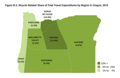
Since my ride on the Springwater Corridor, I’m happy to report that my bike hasn’t returned to hibernation – not after the accomplishment I felt pedaling 25 miles of the Historic Columbia River Highway and State Trail between Corbett and Cascade Locks during August’s policymakers’ ride. In mid-September, just before the rains came, I rode from downtown Gresham to Edgefield with policymakers from Gresham, Fairview, Wood Village, and Troutdale, traveling the Gresham-Fairview Trail and other existing and planned routes through east Metro-area cities.

These first-hand experiences have shown me the enormous potential we have here in East Multnomah County to connect the routes we have, such as linking the Springwater Trail to Troutdale, and the Gresham-Fairview Trail to Marine Drive. But they’ve also given me a personal reason to see our Initiative succeed. Now that I’ve rediscovered the afterglow of biking with friends and colleagues – celebrating our efforts afterward over excellent bites, drinks, and service – I’m looking forward to inviting friends to join me on some of the new itineraries that come out of the Bicycle Tourism Studio Workshop. They’ll be so surprised when I suggest a ride!

* In November, the Gresham Area Chamber will host two Bicycle Tourism Studio Workshops in partnership with Travel Oregon. Please join us November 13 from 9 a.m. to 4 p.m. at McMenamin’s Edgefield or November 14 from 9 a.m. to 1 p.m. at the Corbett Fire Hall. Visit our project webpage to register for the workshops, learn more about the Initiative, or to get in touch with Heidi Beierle, our Project Coordinator.

Alison Hart, Gresham Area Chamber of Commerce CEO, serves on the Oregon State Chamber of Commerce Board and chairs the East Multnomah County Tourism Advisory Committee.  She has over 21 years of experience in private sector and non-profit marketing, event planning, and community building programs.

Foot trackers

Three new findings show us the way of our trails

August 28 2013

In the Portland/Vancouver region, we’re proud of the nature in our backyard. This love of nature ties our cities and counties together, literally, in the form of The Intertwine – our shared system of trails, parks and natural areas.

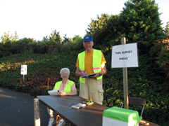
But who’s actually using our trails? How many of us? And why? For one week each September, Metro mobilizes a small army of dedicated volunteers for Trail Counts that attempt to answer these very questions. In a two-hour count session, volunteers armed with clipboard at dozens of key trail locations across the metro region record when someone passes their line, their mode of transportation, and their gender. Through this collective effort, we can document changing patterns of trail use, provide data to support future trail investments, and shed light on who in The Intertwine is taking most advantage of our great trails network.

Following methods recommended by the National Bicycle and Pedestrian Documentation Project, Metro has collected trail use data since 2008. Recently we crunched Metro's historic trail count database to compare user volumes between trails, extrapolate two hour counts into annual totals, and tease out trail corridor trends and patterns for a just-released Intertwine trail use snapshot. What did we learn? Among other things, the following three findings:

1) Riverfront Trails are the Most Popular

Five of The Intertwine's top six highest use trails are located along the Willamette or Columbia Rivers. The Waterfront Park Trail and the Eastbank Esplanade in downtown Portland lead the pack by far, with over three times the volume of the next highest use trail: the Springwater Corridor along the Willamette River.


2) Everyone Walks

Gender is balanced among walkers on The Intertwine. While people tallied on foot are split evenly between male and female, the numbers for cyclists are significantly more lopsided, with females accounting for just 29 percent of riders. A note that this number is for the Intertwine system as a whole; data for some corridors evidenced a more equitable gender distribution. For example, 43 percent of the observed users on Clark County's Columbia River Renaissance Trail were female. 

3) If You Build It, They Will Come

The story of the Trolley Trail makes a great case for building and enhancing trails in our communities. Until 2012, the so-called Trolley Trail was a brambly pathway along an abandoned trolley line in Milwaukie. While in use by neighborhood pedestrians over the decades following the trolley era's sunset in the 1950s, the Trolley Trail failed to live up to its full potential as a transportation and recreation corridor, with a pathway muddy most months of the year and overgrown with blackberries and other weeds. 

In 2012, the Trolley Trail was developed into a fully paved shared-use path to conform to national standards. The change in atmosphere was significant, with usage levels boosted to match. The huge increase in use over 2012 offers us a promising peek at the potential of other similarly unfinished trail corridors – for example, the North Portland Greenway.

So what should we take from these three initial findings from Metro Trail Count data? We know that trails enhance communities across The Intertwine through access to nature, opportunities for physical activity, and options for transportation. And we know that counting counts – helping us track where we've been, learn from past successes, and forge ahead with new trails. We don't yet know where trail count data will lead. But if you join us Sept. 10-15, you can help inform that future.

Nick Falbo is a planner at Alta Planning + Design and founding partner of the National Bicycle and Pedestrian Documentation Project. His experience includes bicycle/pedestrian master plans, complete streets, and Safe Routes to School projects. Metro contracted Nick to work on the Intertwine Trail Use Snapshot 2008-2012 as part of its Regional Active Transportation Plan

Pages

Subscribe to RSS - Fit City